

- All
- Product Management
- News
- Introduction
- Corporate Network
- FAQ
- Corporate Video
- Corporate Brochure

China Water Resources Newspaper focuses on reporting: Naruida Radar uses "hard technology" product innovation to help ensure the safety of rivers
On April 4, China Water Resources Newspaper published an article focusing on "Naruida Radar Uses 'Hard Technology' Product Innovation to Help Ensure the Safety of Rivers and Lakes". The article provides an in-depth explanation of how phased array hydrological rain radar uses technological innovation to build the first line of defense for rainfall monitoring, forecasting and warning, helping to safeguard rivers and lakes, which has attracted widespread attention from all sectors of society.
Publish Time:
2025-04-08 18:17
Source:

On April 4th, China Water Resources News published a report focusing on "Naruida Radar's contribution to river safety with its 'hard technology' product innovation." The article provides an in-depth explanation of how phased array hydrological rain radar uses technological innovation to build the "first line of defense" for rainfall monitoring, forecasting, and early warning, helping to safeguard rivers and causing widespread social concern.
The full text is shared below:
Against the backdrop of intensifying global climate change, China has frequently experienced unprecedented floods. Traditional monitoring and forecasting methods can no longer meet the current needs of flood defense work, making flood prevention a major issue concerning national interests and people's livelihoods. To ensure the safety of people's lives and property, the "three lines of defense" for rainfall monitoring and forecasting are using technology to build a three-dimensional defense network from the sky to the ground, creating a solid barrier for the safety of people's lives and property.
Creating New Productivity with Phased Array Rain Radar
Guangdong Naruida Radar Technology Co., Ltd. (hereinafter referred to as Naruida Radar) is a high-tech enterprise that independently possesses the core technology of fully polarized multi-functional active phased array radar and has achieved industrialization. It is also one of the few companies globally that masters the full value chain system solutions for phased array radar design and manufacturing, radar software ecology, and radar algorithm services, ranging from microstrip patch array antennas, radio frequency front ends, digital intermediate frequency back ends, signal processing, and data fusion to radar data product development. Naruida Radar's product research and applications have been identified as "internationally advanced" by the China Radar Industry Association and have won the Gold Award of the 10th World Radar Expo and the First Prize of Scientific and Technological Progress of the China Radar Industry Association in 2023.
Naruida Radar's independently developed X-band dual-polarization phased array rain radar, with its unique radar operation method, strong ground clutter suppression capability, and dual-polarization particle phase identification capability, achieves stronger rainfall estimation capabilities. As a vanguard of the "three lines of defense," it has played an important role in promoting the hydrological application of "forwarding the front line and pushing the defense line forward."

Image: Fully Polarized Active Phased Array Radar R&D Innovation Center and Industrialization Project
A Full-Process Integrated Software and Hardware Service System
Naruida Radar is committed to the deep integration of rain radar and hydrological applications, building a "rain radar, data, algorithm, application" full-process integrated software and hardware service system. This system, through independently developed high-precision rain radar equipment, intelligent data processing platforms, and algorithm models, provides application support for the high-quality development of "four predictions" and "digital twins."
The technological advantages of phased array hydrological rain radar empower backend applications. The phased array rain radar is based on microstrip patch antenna polarization phased array multi-beam radar technology. Using polarized microstrip patch antennas as the foundation, it integrates multiple advanced radar technologies such as polarization arrays, pulse Doppler, pulse compression, and frequency agility to achieve independent transmission and reception of polarized electromagnetic waves, amplitude and phase control, and all functions such as signal processing and in-machine calibration, giving the system core advantages such as high cross-polarization isolation, low sidelobes, and high polarization consistency.
The phased array rain radar has the characteristics of high spatiotemporal resolution rainfall monitoring, stable operation under extreme weather conditions, and a high level of automation. It can complete the scanning of the entire detection range within 40 seconds, with a spatial resolution of ≤30 meters × 30 meters and up to 43 spatial elevation layers. This technology achieves high-precision polarized phased array fast multi-beam scanning and ultra-high spatial resolution capabilities.
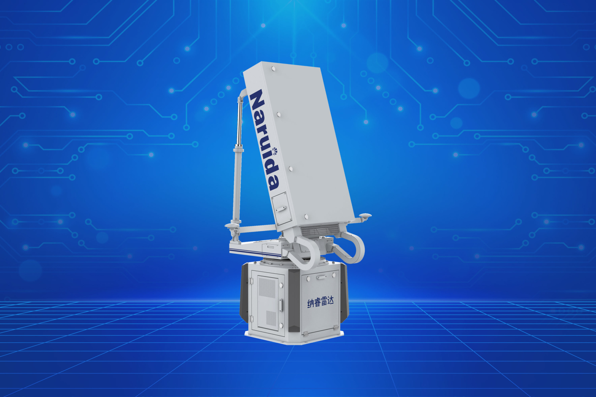
Image: Naruida Radar's independently developed dual-polarization active phased array hydrological rain radar
All-weather maintenance and support, enabling unattended operation. Naruida Radar has built a complete intelligent maintenance management system for phased array rain radar, achieving intelligent monitoring and maintenance of the entire chain from hardware devices to software applications. The system collects and analyzes in real-time the operating data of all chain nodes, including radar operating status, data transmission network, power supply system, data processing server, and application software, providing users with panoramic visualization monitoring of equipment status. When the system detects an anomaly, it can automatically trigger a multi-level alarm mechanism and quickly locate the root cause of the fault based on intelligent diagnostic algorithms. At the same time, the system integrates intelligent inspection, data governance, and automatic report generation, greatly improving the efficiency of daily inspection, data management, quality control, and report output, truly achieving intelligent and integrated maintenance management of phased array rain radar.
Fine-grained areal rainfall monitoring and forecasting capabilities. The phased array rain radar has the advantages of high spatiotemporal resolution, fast scanning, and precise monitoring, enabling real-time fine-grained monitoring of rainfall systems, especially improving the monitoring capability of disastrous rainstorms in complex terrain. The system's output of 40-second and 30-meter gridded areal rainfall monitoring products provides fine-grained support services for areas of concern to water resources users, allowing relevant departments to timely monitor the actual rainfall and evolution trends in key areas and automatically issue warning information for areas affected by heavy rainfall.
At the same time, based on quantitative rainfall monitoring data from hydrological rain radar, the system can also provide near-term rainfall forecasting services for water resources, providing predictions of the movement and changes in the rainfall field over the next 3 hours. Near-term extrapolation forecasting products based on rain radar can inherit the fine-grained characteristics of rain radar data, achieving 100-meter-level forecasting capabilities, which, compared to other kilometer-level forecasts (such as regional numerical model forecasts), can significantly improve the fineness of the forecast.
Mature and complete rain radar hydrological application software ecosystem. Naruida Radar, with high-precision rain radar as its core, deeply integrates advanced technologies such as big data and artificial intelligence to build a full-chain rain radar hydrological application software system from data acquisition, analysis, and processing to early warning, forecasting, business evaluation, and decision support.
The phased array rain radar full-link data intelligent control system can provide full-link radar data monitoring, data push, radar status inspection, and other services, realizing intelligent and automated reliable maintenance work. The rain radar short-term near-term fine-grained areal rainfall forecasting and early warning software focuses on the display and analysis of rain radar rainfall products, providing functional services such as fine-grained grid rainfall monitoring and forecasting. The AI precipitation process management system assists business personnel in comparing and testing rain radar rainfall monitoring and forecasting products, laying the foundation for better formulating flood forecasting plans.
Significant Results from Hydrological Rain Radar Applications
During the Haihe River "23.7" basin-wide major flood, Naruida Radar's hydrological rain radar fully captured the spatial distribution characteristics of this rainfall process, and the radar-estimated rainfall had a small error and low dispersion compared to hourly rainfall from rain gauges.
Since 2022, pilot tests in the Laodao River and Liuyang River basins in Hunan Province have shown that flood predictions incorporating weather radar data are largely consistent with actual flood trends. On June 20, 2023, a Hunan phased array hydrological weather radar accurately captured the overall details and contours of rainfall regions, and the rainfall centers of the QPE (Quantitative Precipitation Estimate) products were also consistent with rain gauge readings, proving the effectiveness of hydrological weather radar and its accompanying QPE algorithm in capturing intense rainfall processes in mountainous pilot areas. During the 2024 flood season, based on weather radar data, 10 automatic risk early warnings for small river-induced floods and disasters were effectively issued, with an average lead time of 2.5-3 hours, playing an important role in flood control and disaster reduction during the flood season.
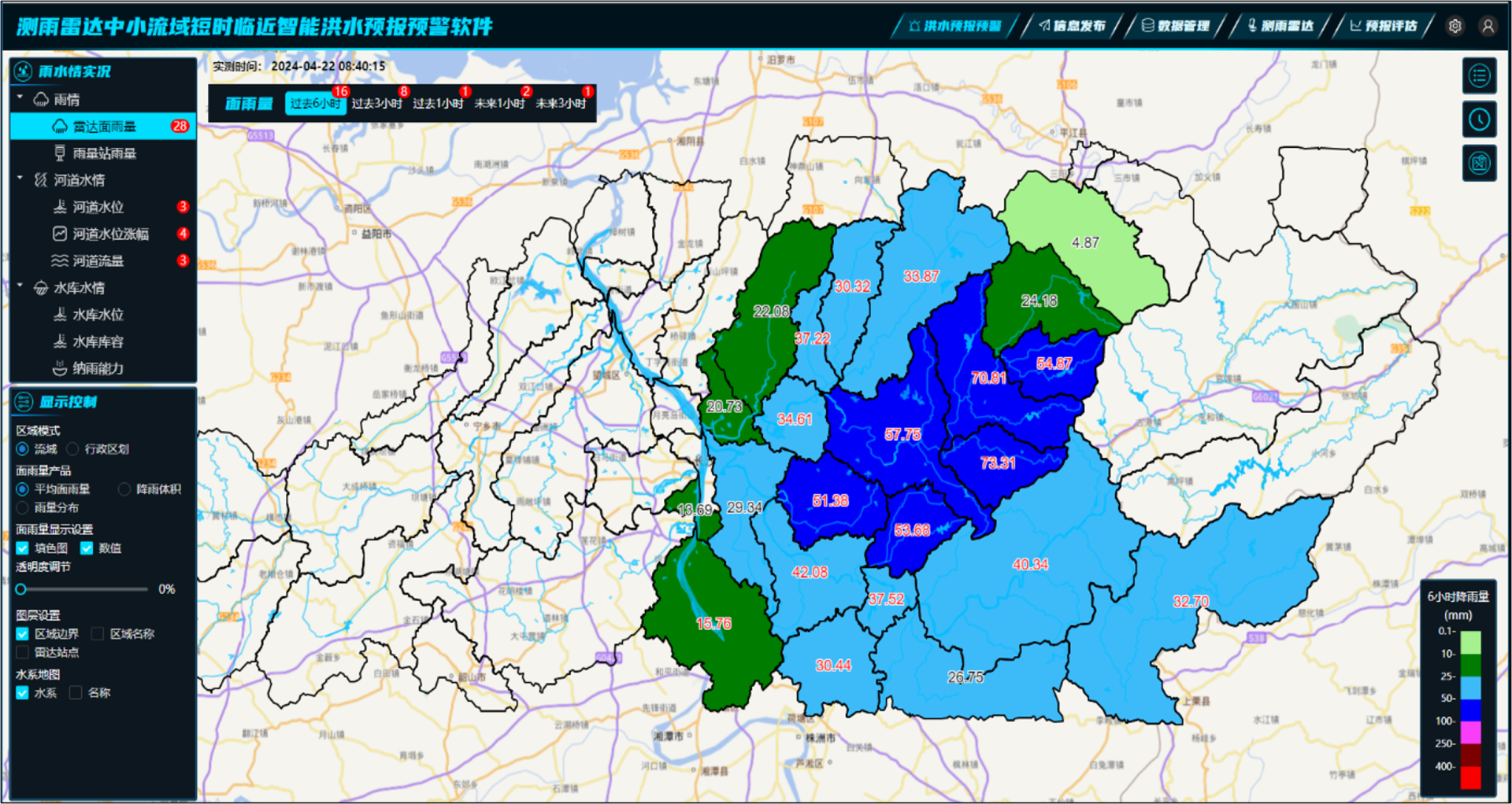
Figure | Hunan Province Weather Radar Software for Short-Term and Near-Term Intelligent Flood Forecasting and Early Warning in Small and Medium-Sized River Basins
During the 2024 flood season, three networked radars in the Yongding River basin of Beijing successfully achieved network applications. These radars enabled continuous, high-precision, and high-resolution monitoring of rainfall intensity, structure, and trends in key areas. They could promptly issue alerts on the location and intensity of heavy rainfall, complementing and supporting other "two lines of defense" rain gauges and hydrological stations. In July 2024, Beijing experienced two consecutive periods of heavy rainfall, showcasing the initial effectiveness of the Yongding River Guanting Gorge section's three networked hydrological weather radars. Compared with actual rainfall, the radar's 1-hour and 2-hour rainfall forecasts had an accuracy rate exceeding 80%. In addition, the real-time monitoring of heavy rainfall centers and intensity by the radar corresponded well with rain gauge monitoring.
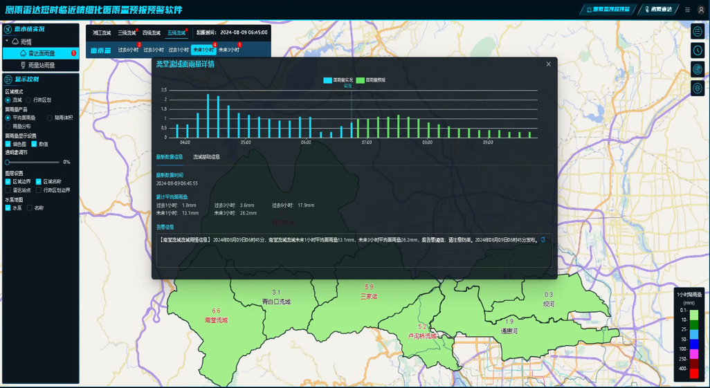
Figure | Beijing Weather Radar Software for Short-Term and Near-Term Refined Areal Rainfall Forecasting and Early Warning
In August 2024, a phased array weather radar network was established in the Xiaolangdi reservoir area, and radar data was integrated into the Xiaolangdi weather radar software for short-term and near-term intelligent flood forecasting and early warning in small and medium-sized river basins, providing stronger support for ecological protection and high-quality development of the Yellow River basin and ensuring the safety of life and property for people in the middle and lower reaches of the Yellow River.
During typical heavy rainfall events in September and October 2024, Shandong Hydrology used weather radar to monitor and forecast "in-cloud rainfall," accurately grasping the movement direction of rain bands, monitoring their development and dissipation, and obtaining timely information on changes in areal rainfall in the basin. This provided accurate data support for hydrological monitoring analysis; utilizing the radar's 1-3 hour high spatiotemporal resolution rainfall forecast results effectively enhanced the perception and early warning capabilities for short-duration heavy rainfall. In combination with the Shandong provincial flood forecasting system, the flood forecasting lead time was effectively extended, providing strong support for flood prevention decisions and dispatching, seizing the initiative, and ensuring the safety of people's lives and property.
By the end of October 2024, three hydrological weather radars at the Datengxia Hydropower Hub project achieved networked operation six months ahead of schedule, expanding the rainfall detection range and helping advance rainfall and water situation monitoring and forecasting, pushing the defense line further outward.
By the end of 2024, three phased array hydrological weather radars were deployed in Maoming City, Guangdong Province, and networked for collaborative observation. This mainly involved an ultra-fine areal rainfall monitoring, forecasting, and early warning system focusing on the active areas of intense rainfall in the near-ground layer within 2 kilometers of the middle and upper reaches of the Jianjiang River, the upper reaches of the Huanghua River, and the Rudong, Tanshui, and Bajia rivers. This comprehensively improved the monitoring, forecasting, and early warning capabilities for flood and drought disasters in the basin, providing reliable hydrological support for flood and drought prevention and mitigation.
As an innovator and leader in the field of flood disaster prevention systems, Naruida Radar, with its ardent care for people's livelihood, is deeply involved in water conservancy projects and understands the critical importance of flood disaster prevention. Through technological and product innovation, it deeply integrates the latest active phased array radar technology with the "four predictions" (forecasting, early warning, simulation, and pre-planning) needs, helping to improve the modernized rainfall and water situation monitoring and forecasting system, and contributing to the safety of rivers.
Related News
Naruida Radar (stock code: 688522) is included in the SSE STAR 200 Index
The Shanghai Stock Exchange (SSE) recently announced the official launch of the SSE STAR Market 200 Index on August 20, 2024, to reflect the performance of listed securities on the STAR Market in a timely manner and provide the market with multi-dimensional investment targets and performance benchmarks. Naruida Radar Technology Co., Ltd. (hereinafter referred to as "Naruida Radar", stock code: 688522) in Guangdong Province has been honorably selected as a constituent stock of the SSE STAR Market 200 Index.
Naruida radar products attract widespread attention and reporting from mainstream media
In recent years, the company's products have achieved significant technological innovations and positive application results in meteorological detection, water conservancy monitoring, low-altitude economy, civil aviation, marine monitoring, and public safety, attracting extensive attention and focused reports from major mainstream media outlets such as CCTV, People's Daily, and Xinhua News Agency.
On April 4, China Water Resources Newspaper published an article focusing on "Naruida Radar Uses 'Hard Technology' Product Innovation to Help Ensure the Safety of Rivers and Lakes". The article provides an in-depth explanation of how phased array hydrological rain radar uses technological innovation to build the first line of defense for rainfall monitoring, forecasting and warning, helping to safeguard rivers and lakes, which has attracted widespread attention from all sectors of society.
On August 27, the first council meeting of the Greater Bay Area Low-Altitude Economy Industry Alliance was held in Guangzhou. The meeting voted to approve relevant deliberation items, including the alliance structure, articles of association, council positions, and future key work directions. Guangdong Naruida Radar Technology Co., Ltd. was selected as the vice chairman unit of the alliance, and Chairman Bao Xiaojun was selected as a member of the alliance's expert committee.
In recent days, the networking of three hydrological meteorological radars at the Datengxia Project has attracted social attention, with major media outlets such as CCTV, People's Daily, and Xinhua News Agency focusing on reporting the event.
Recently, the construction demonstration zone for low-altitude applications in Yantian and the launch ceremony for the Yantian Low-Altitude Application Service Management System were successfully held at the Yantian eVTOL Industrial Park in Shenzhen. Naruida Radar's TDKFT0104 Ku-band dual-polarization multi-purpose radar served as the primary low-altitude detection equipment in the platform system construction. It is understood that the Yantian Low-Altitude Application Service Management System is the first officially released low-altitude management system (1.0) in Shenzhen.
Guangdong Naruida Radar Technology Co., Ltd.
Official Account QR Code
Guangdong Naruida Radar Technology Co., Ltd.
Service hotline:
Company Address:
No. 2, Gang Le Road, Tangjiawan Town, Zhuhai City, Guangdong Province


COPYRIGHT 2025 Guangdong Naruida Radar Technology Co., Ltd.
 No. 44049102496558
POWERED BY 300.CN Privacy Policy