

- All
- Product Management
- News
- Introduction
- Corporate Network
- FAQ
- Corporate Video
- Corporate Brochure

WebGIS 3D data visualization software
WebGIS three-dimensional data visualization software (WebRD) is a B/S architecture-based comprehensive meteorological application software developed using WebGIS and WebGL technology. The system can realize two-dimensional or three-dimensional visualization of radar data, and provide meteorological analysis, severe weather warning, historical data viewing, weather process management and other functions, providing users with one-stop application services for meteorological monitoring, forecasting and warning.
Category:
Keyword:
Product Details
WebGIS 3D Data Visualization Software
1) Software Introduction
WebGIS 3D data visualization software (WebRD) is a meteorological comprehensive application software based on B/S architecture, developed using WebGIS and WebGL technology. The system can realize two-dimensional or three-dimensional visualization of radar data, and provides meteorological analysis, severe weather warning, historical data viewing, weather process management and other functions, providing users with one-stop application services for meteorological monitoring, forecasting and warning.
2) System Interface
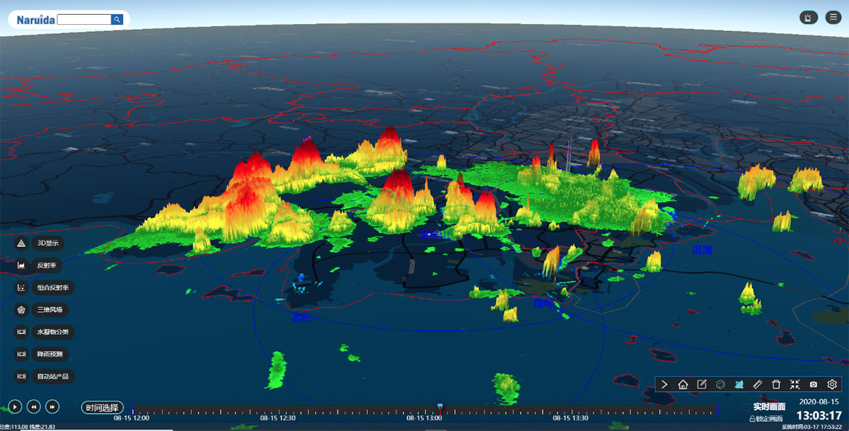
Three-dimensional composite reflectivity
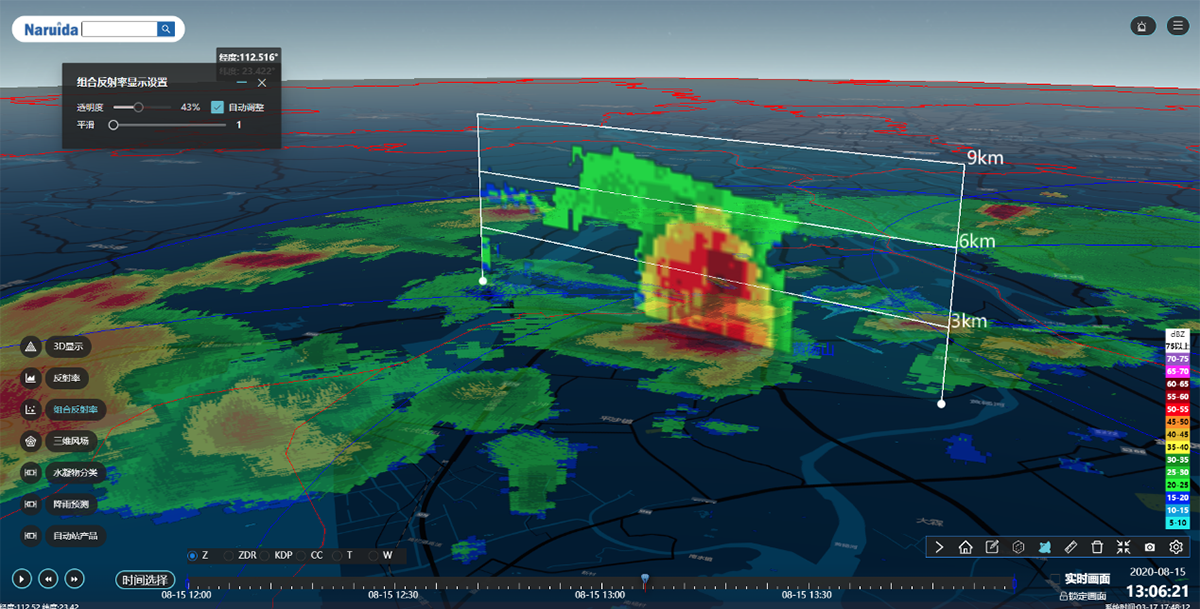
Arbitrary vertical cross-section
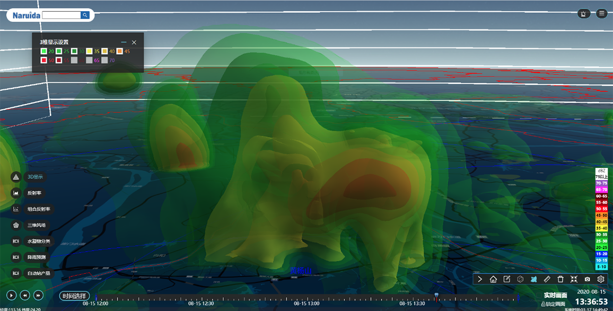
Three-dimensional radar echo
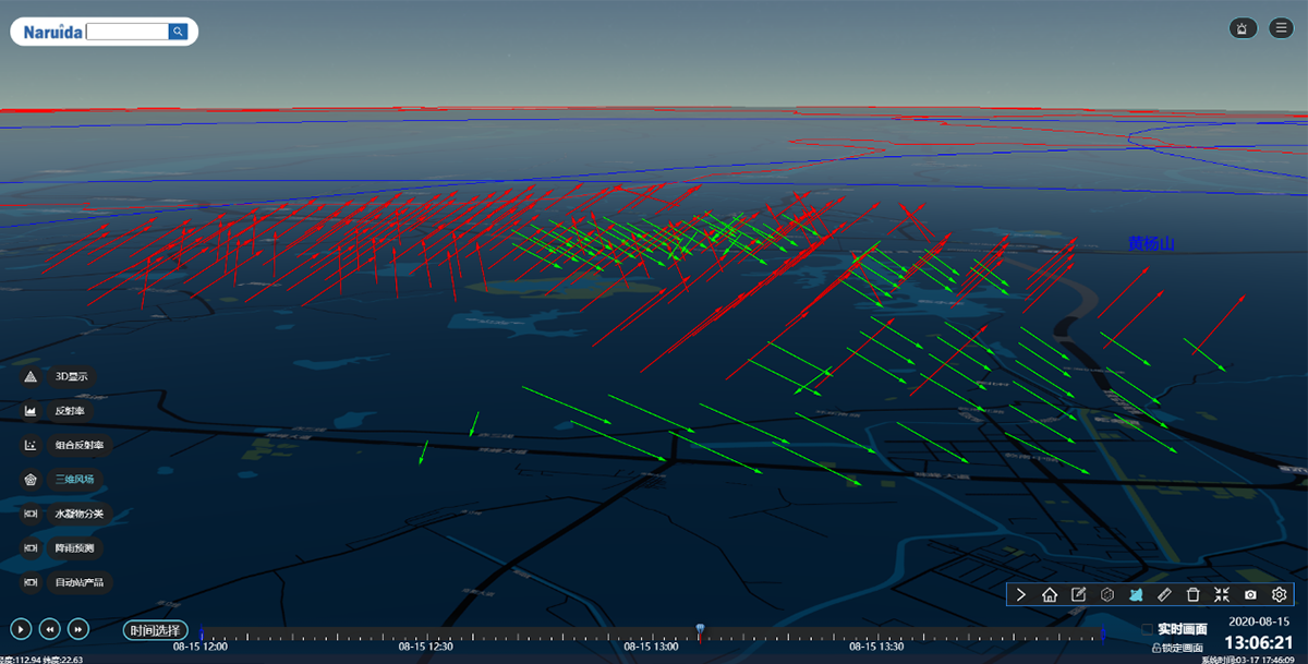
Three-dimensional wind field inversion
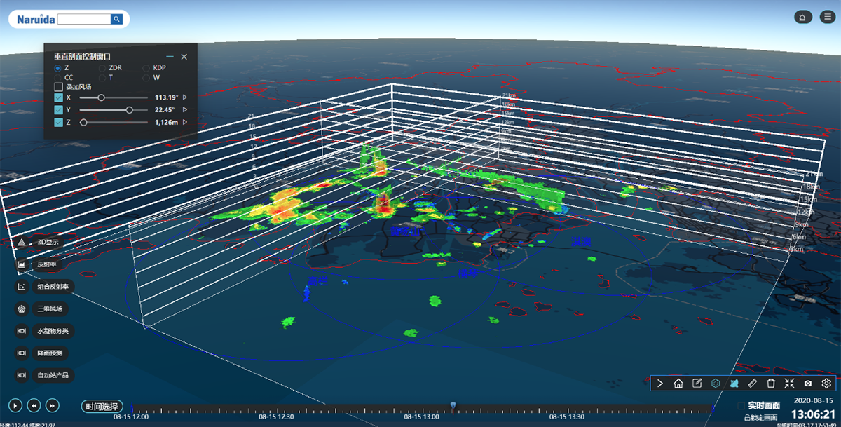
Three-dimensional profile
3) Functional Characteristics
· Rich 2D and 3D radar product visualization functions
· Radar data and geographic information fusion display based on the WebGIS platform
· Exquisite interface and user-friendly human-computer interaction
· Intelligent weather monitoring and warning
· Weather process management
· Historical product data viewing
· Comprehensive monitoring data fusion display.
Related Products

The WDSPT0152 radar is an S-band fully polarimetric active phased array meteorological radar product independently developed by Guangdong Naruida Radar Technology Co., Ltd. to meet the needs of high spatiotemporal resolution and refined detection of large-scale and full-scale weather processes. Based on the refined and rapid detection capabilities of digital active phased array radar, this product integrates the advantages of multiple radar systems, including digital beamforming (DBF), pulse Doppler, pulse compression, and frequency agility. It can effectively address the challenges in early warning and forecasting of full-scale, high-impact weather systems such as storms, thunderstorms, strong winds, short-duration heavy rainfall, wind shear, and tornadoes, thereby comprehensively improving the meteorological department's prediction capabilities, reducing casualties and economic losses caused by meteorological disasters, and providing effective meteorological security services for national economic and social development.
The WDCPT0152 C-band fully polarimetric active phased array weather radar is a fully polarimetric active phased array weather radar product independently developed by Guangdong Naruida Radar Technology Co., Ltd. for meteorological departments, air traffic control meteorology, research institutes and other users. Based on the refined and rapid detection capability of digital active phased array radar and the full polarization particle phase identification capability, this product can more precisely capture and analyze the complete structure of the internal disaster weather system, and more meticulously analyze the shape, phase, and spectral distribution of precipitation particles and other microphysical characteristics, providing detection basis for accurate and timely meteorological disaster early warning, thereby reducing casualties and economic losses caused by meteorological disasters, and providing effective meteorological security services for national economic and social development.
The AXPT0464 is a fixed, multi-functional dual-polarization active phased array radar that can simultaneously detect meteorological phenomena and targets. This radar not only provides detailed weather system forecasting and warning information, but also simultaneously provides precise target detection, identification, positioning, angle measurement, tracking, and warning functions. In a single scan, it can simultaneously obtain high spatiotemporal resolution meteorological information and various flight target information from the observation airspace. It has multi-functional fusion observation advantages in addressing integrated meteorological/target service areas, effectively solving problems such as refined target detection, control, and early warning services for "civil aviation and general aviation air traffic control" and "low, slow, and small threat flight targets" that are easily affected by severe weather.
Guangdong Naruida Radar Technology Co., Ltd.
Official Account QR Code
Guangdong Naruida Radar Technology Co., Ltd.
Service hotline:
Company Address:
No. 2, Gang Le Road, Tangjiawan Town, Zhuhai City, Guangdong Province


COPYRIGHT 2025 Guangdong Naruida Radar Technology Co., Ltd.
 No. 44049102496558
POWERED BY 300.CN Privacy Policy